


- “A survey” is not one thing. The quote you get depends on which one you asked for, often without knowing you asked.
- Five surveys cover most household questions: boundary, detail, set-out, engineering and volume. The question decides which one you need, not the size of the block.
- A surveyor does not invent a boundary. They re-establish the one the recorded plan already created, working from evidence in the ground and from the record.
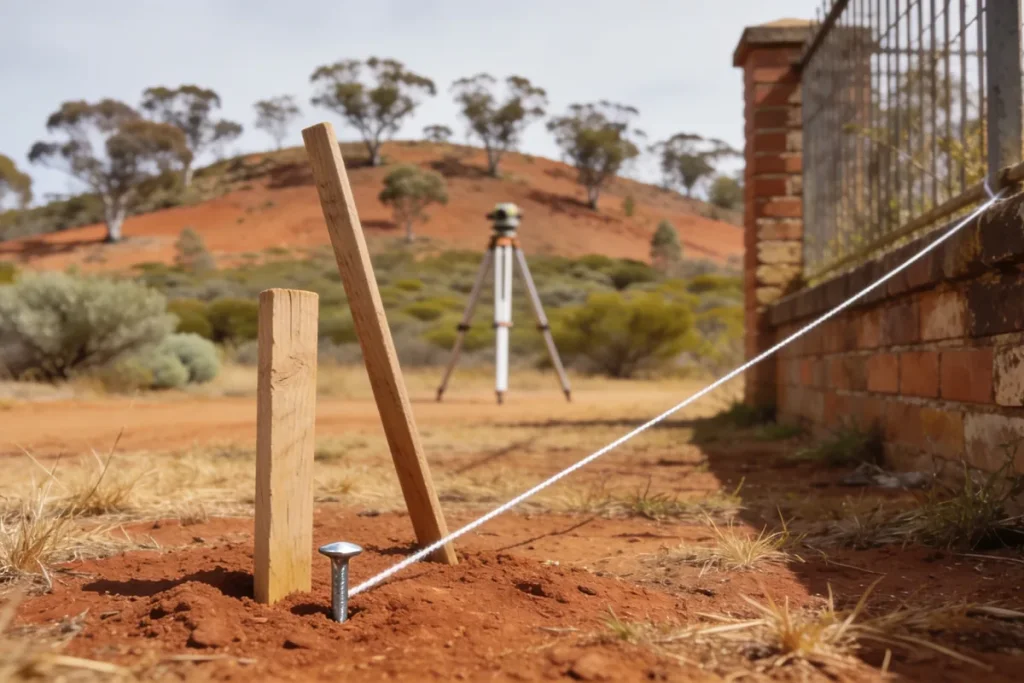
- The peg is the mark, and the taller stake beside it is only there so somebody can find it. Fences, retaining walls and garden beds are not evidence of where the line runs.
- Plenty of people do not need a survey at all. The test is whether there is a question that only a survey can answer.
The quote arrives as “a survey”, and the number next to it is real. What that number buys, though, depends entirely on which survey it is, and the words on the quote are often the first time a homeowner has seen the subject broken into categories at all. This article separates them. It covers what each survey does, what a boundary survey is really re-establishing when a peg turns up in the yard, how to read the plan you may already have in a drawer, and how to tell when none of it is needed.
Which survey is this?
Choose the situation you are in and this will name the survey that answers it. Every situation below is a question, not a rule, and the surveyor will confirm which one fits your block.
If this does not load: write down the question you are trying to answer. If it is where the line is, you want a boundary survey. If it is what exists on the site, you want a detail survey. If it is where the building goes, you want set-out. If it is levels or services, you want an engineering survey. If it is how much material is there, you want a volume survey.
- What are you trying to find out? (Where my land ends / What is on the block, for a design / Where the building, pool or shed actually goes / Levels, drainage and services for works / How much soil, rock or stockpile is there / Something is moving or has moved / I do not know yet)
- What is prompting this? (Buying or selling / Building or renovating / A fence or a neighbour / Subdividing or developing / An argument about earthworks / Nothing yet, just working out what is involved)
This is a guide to which survey answers which question. It is not a survey, it is not advice about your boundary, and it does not tell you where anything is. Confirm what you need with a registered surveyor and, where a boundary is in question, with the appropriate authority in your state.
Nothing here is calculated for you. Every answer comes from what you chose.
If you have found a peg and a taller stake at the same corner, the peg is the mark and the stake is only there so it can be found.
A survey is an answer to a question
Nobody buys a survey. They buy the answer to a question, and the question is the thing to identify first.
Where does my land end, and does what has been built agree with it? That is a boundary or identification survey, and it is the one this article spends the most time on, because it is the one that carries the most feeling and the least published explanation.
What is on and around this block, for a design? That is a detail or feature survey. It records levels, structures, trees, services and the neighbouring buildings that a designer, architect or engineer will need to work from.
Where does the building, the pool or the shed actually go? That is construction set-out, and it is the step where a drawing stops being a drawing.
What are the levels, services and drainage doing across this site, for works rather than for a house? That is an engineering survey. Often that one is met as a line on somebody else’s quote rather than as a purchase of its own.
How much material is there, and how much has moved? That is a drone or volume survey, which sounds like an industry tool and turns up in ordinary situations, such as a stockpile that needs measuring or a dispute about earthworks.
If two of those questions feel like yours, that is normal, and it does not mean you need two surveys. It means the conversation should start with the question you are trying to answer today.
The pattern is simple and it is worth saying plainly. A reader who asks for “a survey” without a question will be quoted for whatever the firm guesses, and that is how people end up paying for something that does not answer the thing they wanted to know.
What a boundary survey actually does
Start with the honest sequence, because most of the confusion lives here. A surveyor does not invent a boundary. The boundary was created by the recorded plan of the subdivision, and the surveyor’s job is to re-establish that line, working back from evidence in the ground and from the record of what was originally set out.
That reframe matters, because it explains the physical things a reader finds in the yard afterwards, and which almost nobody is told how to read.
The peg and the nail. The nail, set in the corner of the shorter peg, is the point. The taller stake beside it is only there so that somebody can find it again. Two markers at one corner, and the smaller, plainer one is the one that counts.
The line between two pegs. That is the boundary, drawn through the air from corner to corner. It is a line of position, not a fence, and the two are frequently not in the same place.
The marks on fences and walls. Surveyors leave reference marks on existing structures so that a future surveyor can recover the same line again. Their entire value is in being left where they are put.
That is why two neighbours can both be sincere and still disagree: each is reading the same line from a different side of it, and neither of them is looking at a document that settles the question.
Now the sentence that matters most, and it comes from how common the situation is rather than from any rule: fences, retaining walls, garden beds and driveways are not evidence of where the boundary is. They are evidence of where somebody once built something. The two commonly disagree, and a reader who has found a peg in an unexpected spot has usually discovered exactly that situation and nothing more dramatic.
None of this tells you anything about your own block, and this article will not try to. It says only that the line and the fence are different kinds of thing, and that the only reliable answer for a specific property comes from a surveyor establishing it on the ground.
When you actually need one, and when you do not
The triggers are worth recognising, because they are usually situations rather than preferences.
You are buying. The plan of the block and what is actually built on it are two different documents, and the survey is how the second one gets checked against the first. The sooner it is done, the more time there is to deal with whatever it finds.
You are building, extending, or putting in a pool or a shed. What matters then is the setback and the levels, which is a different survey again, so the quote should be for the survey the project needs rather than the one the phrase suggests.
You are fencing, or the neighbour is. The only way to know where the line runs is to have it established, and this is the moment people most often discover that the fence is not where they assumed it was.
You are subdividing or developing. The boundary survey is the first of several steps, and the recorded plan comes later rather than first. The order matters more here than anywhere else on the list, because each of the later surveys builds on the first one, and a shortcut at the start shows up at the end.
Something is moving. A wall, a slab, a driveway that has changed shape or level is a monitoring question, and it is a different job from any of the above.
Then the honest counterpoint, which a firm’s own page will rarely say out loud. Plenty of people do not need a survey. If nothing is being built, bought, divided or disputed, an old plan and a tape measure often settle the question that prompted the thought, without commissioning anything at all. The test is not whether a survey would be interesting. It is whether there is a question that only a survey can answer.
The other surveys, and who actually commissions them
The boundary survey is the one a household buys. The rest of the list is what happens next on a project, and it is worth understanding because it is where the sequence sits.
Detail and feature surveys are what a designer, architect or engineer works from. They capture the existing conditions of a site: levels, trees, services and the neighbouring structures that a design has to live with.
Construction set-out is the step where the drawing stops being a drawing. Pegs, marks and levels go onto the ground in the right place, and set-out is the reason a building ends up where the plan said rather than near enough.
Engineering and infrastructure surveys cover roads, drainage, services and levels on works that are not houses, and they are commissioned by whoever owns the works rather than by a householder.
Drone and volume surveys answer “how much is there” and “how much moved”. That is the question you ask about a stockpile, a cut or a fill, and it is also the question that disputes about earthworks turn on.
Notice how much of that list a household meets second-hand, as part of somebody else’s project rather than as a purchase of its own. Understanding it is still worth the effort, because those surveys decide what happens on the site.
One line on drafting, because it applies to every item above: the drawing is part of the deliverable. A reader should ask what they will receive at the end of the job, and in what form, before the job starts. The relationship between the surveyor and the construction project is its own subject, and the site’s the role of a surveyor in construction projects: from planning to completion covers where the profession sits in a build.
What a plan is, and how to read one
Most established properties have a plan somewhere: in the paperwork from the purchase, in a drawer, or in the records the previous owner left behind. It is more readable than its reputation suggests.
A plan is a drawing with a scale, a north point, dimensions and a lot and plan reference, usually with a few notes. What a reader can take from one without any training is the shape of the block, roughly where the corners sit, and how the block relates to the street. That is genuinely useful. It settles the difference between the block you think you own and the one drawn on paper.
What a plan cannot tell you is equally specific. It cannot tell you whether the pegs in the ground today are the ones the plan intended, and it cannot tell you whether something built since agrees with it. Those are questions about the present, and the plan is a document of the past. The notes on a plan are the part people skip, and they are worth reading: they tend to say what the drawing is, what it covers, and what it does not. Whether an old plan still describes your block is a question for a surveyor, who can compare the paper with what is actually there, and it is worth asking rather than assuming in either direction.
Two practical habits go with this. Read the dimensions from corner to corner rather than from the building, because the corners are what the plan is describing. And photograph the existing marks and pegs before any work disturbs the site, because a mark that has been dug out is a mark that has to be re-established, and a photograph is a small thing to have when the alternative is finding the line all over again. The plan in your hand and the ground outside are the two documents that matter, and comparing them is the surveyor’s job.
The commercial side, in one paragraph
Who pays, who commissions and who holds the result, in the order a household meets them. On a building project the survey is usually commissioned before the design rather than after it, because the design has to sit on real levels and real boundaries. The results belong to the client who commissioned them rather than to the builder, which is worth knowing when somebody asks to keep a copy. And a survey is a snapshot of a moment, not a permanent guarantee, which is the honest description of what it is for. None of that is a reason for suspicion. It is simply how the work is bought, and knowing the order in advance saves an unpleasant conversation later. One line that matters more than the rest: if work starts before the set-out, the survey has been wasted, and the fix belongs before the concrete rather than after it. The site’s how to prep your site for a smooth concrete pour covers the ground side of that sequence.
What to ask before anyone comes out
The compressed version of everything above, in the form of questions to ask before the visit is booked.
What question am I actually asking? Which survey answers it, and why that one rather than another? What will I receive at the end, and in what form? What do you need from me before the visit: the old plan, access, a conversation with the neighbour about crossing, the location of services? And what happens if the answer is not what I expected?
A survey is not a formality you get through before the real work starts. It is the piece of information the real work depends on, and being able to say which survey you need, and why, is the difference between commissioning an answer and buying a guess. It is also the conversation a land surveying company working in Darwin and Perth on boundary, detail and construction surveys has with every client before a job is booked, and it is a better conversation to have before the dig than after it.
Sources consulted: Geoscience Australia positioning information; the relevant state or territory lands authority.